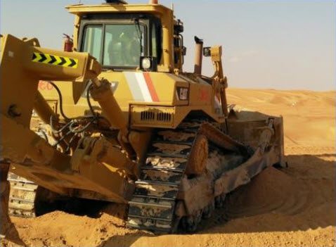
Dozer Site Control & Guidance System
We supply Hemisphere GradeMetrix Dozer Site Control & Guidance Positioning systems.
Dozer Guidance & Positioning Solutions
GradeMetrix Dozer site control and guidance positioning system is packed with easy to use, industry-leading technology at an affordable price and can be installed and calibrated in less than 8 hours.
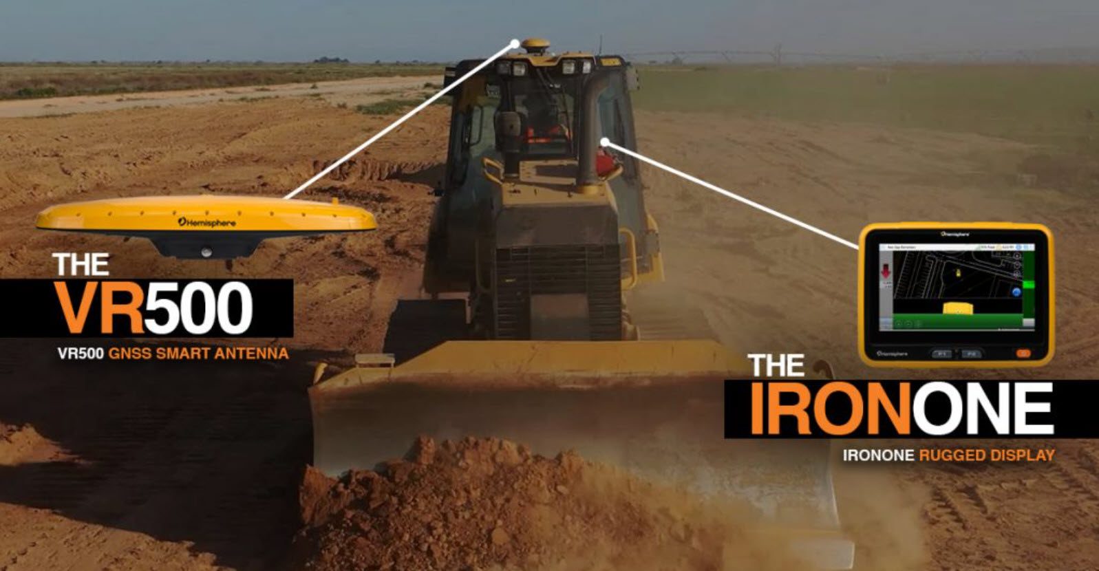
The VR500 all-in-one RTK Smart Antenna supports all machines ranging from smaller compact Dozers and skid steers to large mining Dozers.
The system will fit seamlessly into your existing site infrastructure using the same design file formats and base station corrections. Our best-in-class 3-year warranty covers all major components to ensure your peace of mind.
New and experienced operators can dramatically increase accuracy, efficiency, and dependability with GradeMetrix, resulting in significant ROI in your operations right away.
We service the Newcastle, Hunter Valley, Central Coast, Mid North Coast and some regional NSW areas, send us an enquiry for more information.
How much could you be saving with a Dozer Guidance and Positioning Solution?
Your Benefits At A Glance
- RIGHT FIRST TIME – Less passes – Work faster – Reduced operator skill requirement – Reduced fuel costs
- MATERIAL SAVINGS – Improve transportation cost – Control soil disposal cost
- REDUCED SURVEY COST – Less site preparation – Less checking – Less rework – Less stake replacement
- IMPROVED SAFETY – Less personnel around machines – Operator stays in the machine
- 3-YEAR WARRANTY – Best in class warranty
- EASILY ADAPTABLE – Primary components can be moved easily and quickly between machines
UNPRECEDENTED VALUE IN MACHINE GUIDANCE
GradeMetrix Key Features
Hemisphere’s GradeMetrix Dozer solution is powered by hardware components that have undergone extensive shock, vibration, and environmental testing to withstand the harshest job site conditions.
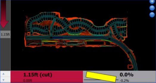
The embedded 2.5D function in GradeMetrix allows you to use the GNSS Guidance Technology for a vast array of simple, useful applications without the need for complex 3D files from a land surveyor.
Using only a few keystrokes, you can easily create simple layers, single or dual slopes, ramps, and even roads, using your GNSS as a reference. Also, using the optional Hemisphere C631 base station, you can provide RTK corrections to your Dozer. No survey points, no local transformations, or projections are needed.
In addition to the 3D model benefits, the 2.5D functionality will significantly speed up your work cycles and dramatically reduce your ROI time.
APPLICATION EXAMPLES
SITE PREPARATION
Course Grading
ROAD CONSTRUCTION
Material Layering
MINING
Pass-2-Pass Guidance
Cost Savings – Effective Immediatly
Hemisphere’s latest multi-frequency, multi-GNSS solution uses all the available satellites in the sky as a standard feature. The solution ensures user access to a robust RTK solution in virtually any environment reducing expensive machine downtime, especially in challenging locations like open-pit mines or urban canyons. GradeMetrix Dozer solutions offer immediate cost savings to your earthmoving activities. The simplified installation and calibration process gets your system up and running quickly.
The GradeMetrix GNSS-based system allows operators to match a slope or extend a pad, ramp or ditch along existing ground features. Create new ramps and basic roads in the field on the display and GO!
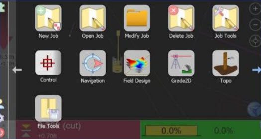
Intuitive Menu Design
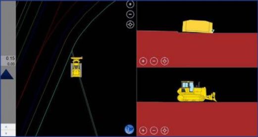
Multiple Views
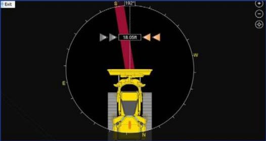
Navigation To A Point
Supports Large DTM’s
RELATED PRODUCTS
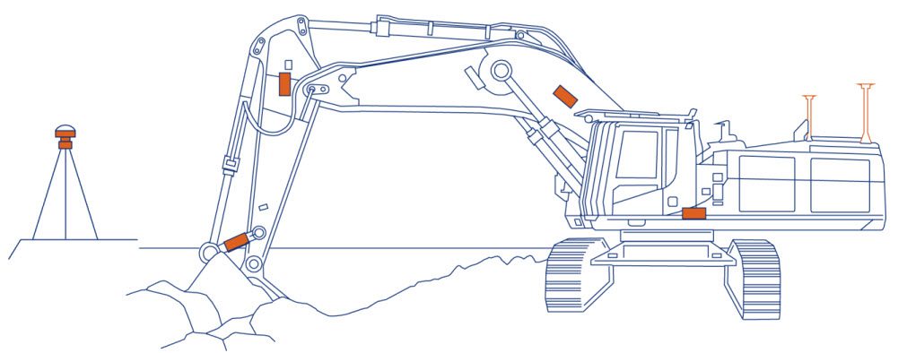
The Dozer Site Control & Guidance System is designed in a unique format centred around the VR500 all-in-one RRTK Smart Antenna. The VR500, with its integrated UHF radio and GNSS receiver, requires a single cable connection to the IronOne display, resulting in the most simplified installation and calibration procedure on the market, and is the result of multiple decades experience merging GNSS technology with precision applications.
An industry-leading 3-year warranty covers all the GradeMetrix system key components. You can have peace of mind and confidence that your GradeMetrix Excavator solution will provide superior results and performance for the long term.
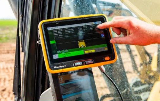
IRONONE Rugged Display
- 8″ (1280 x 720 resolution) Touchscreen
- Microsoft Windows operating system
- Sunlight viewable display
- Easy and intuitive user interface
- Handles large 3D DTM project files
- Wi-Fi, Bluetooth and ethernet support
- Integrated cellular modem for Ntrip corrections or remote/data support
- IP67 rating
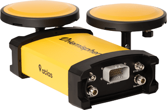
VR1000 GNSS RTK Heading Receiver
- Large Excavator Solution
- Multi-frequency, Multi-GNSS GPS/GLONASS/BeiDou/Galileo/QZSS capable
- Integrated 400 MHz UHF radio
- Powerful WebUI with ethernet, CN, serial, Bluetooth and Wi-Fi connections
- IP69K and MIL-STD-810G
- Rugged GNSS antenna array
- Hemisphere GNSS Athena RTK engine
- Supports Hemisphere GNSS Atlas L-band Correction Service
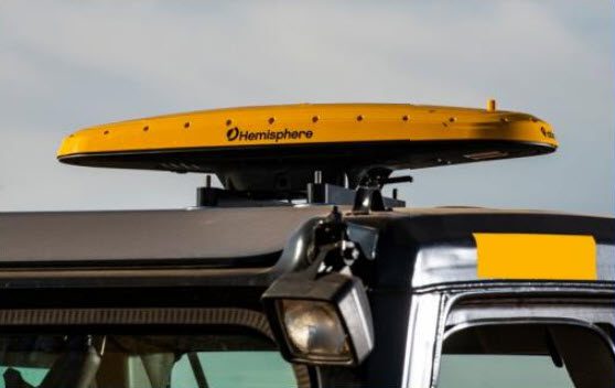
VR500 GNSS RTK Smart Antenna
- Compact Excavator Solution
- Mastless position and heading RTK Smart Antenna for compact excavators
- Multi-frequency, Multi-GNSS GPS/GLONASS/BeiDou/Galileo/QZSS capable
- Integrated 400 MHz UHF radio
- Powerful WebUI with ethernet, CN, serial, Bluetooth and Wi-Fi connections
- IP69K and MIL-STD-810G
- Hemisphere GNSS Athena RTK engine
- Supports Hemisphere GNSS Atlas L-band Correction Service
How much could you be saving with a Dozer Site Control & Guidance System or Excavator GPS Solution? Contact AVE Technologies now for more information and a demonstration. We service Newcastle, Central Coast, Hunter Valley and the Mid North Coast.
Contact Us
Newcastle Office
Hunter Valley Office
Opening Hours
Office Hours
Monday – Friday
7am – 5pm
Request a Callback
Leave your details and a member of the AVE Technologies team will get back to you.
"*" indicates required fields